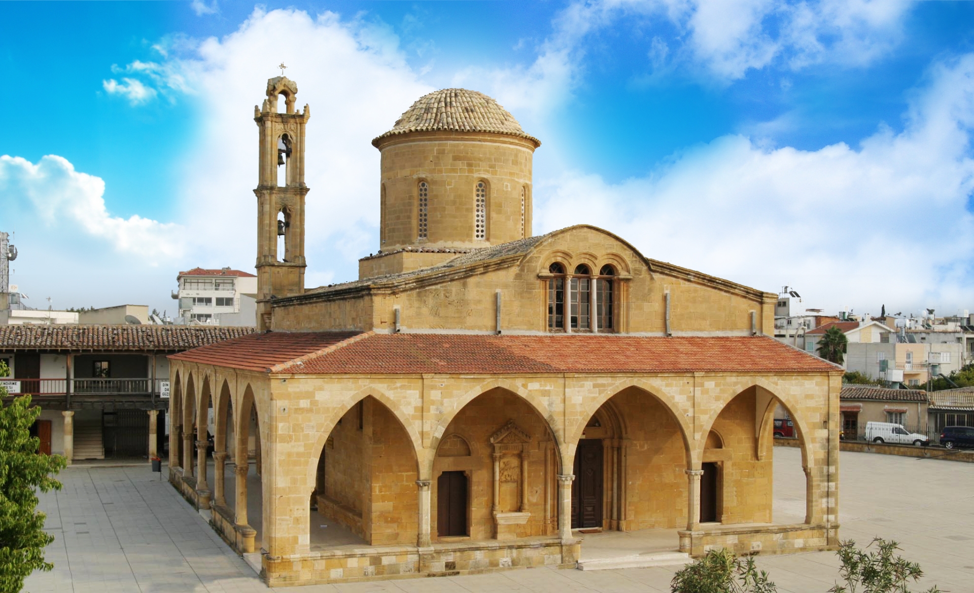

Municipality of Sparta
![]()
Municipality of Sparta
Address: Evangelistrias 85-87
Telephone: 27310 22226, 27310 81866
Fax: 27310 22203, 27310 26772
Email: [email protected]
TWINNING DATE:
Cyprus: 16/10/1993 under Mayor Mr. Andis Pantelidis
Abroad: 24/04/1993 in Sparta
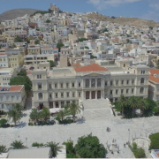
Modern Sparta, the capital of the Prefecture of Laconia, is built on the eastern foothills of Taiyetos, in the wider region of Eurotas valley. It is in the same location as the ancient city. The plain around is surrounded with olive trees, oranges, lemons, mulberries and other trees. To the southwest lays Mount Taygetos with its towering peaks and wild beauty. On the eastern part of the city lies the Parnon mountain range, which is full of firs and other trees.
Municipality of Hermoupolis
![]()
Municipality of Hermoupolis
Address: Miaouli Square, Ermoupoli, 84100, Syros
Email: [email protected]
URL: https://www.syrosisland.gr/
TWINNING DATE:
Cyprus: 29/04/1995 under Mayor Mr. Andis Pantelidis
Abroad: 21/08/1994 in Ermoupolis
THE HISTORY OF SYROS
The story of a Lady
Prehistoric findings in the areas of Chalandriani, Kastri and ancient Galissos prove that Syros had already been inhabited since the 3rd millennium BC. and was heavily commercialized, as evidenced by the first keel ship built in the prehistoric settlement of Chalandriani in 3000 BC, as well as various findings that prove the existence of metallurgical plants and the island’s relationship with Asia Minor. During the 2nd millennium Syros was occupied by the Phoenicians, the Minoan Crete and the Mycenaeans, while in the 1st millennium it passed into the hands of the Ionians. From the 7th to the 3rd century BC traces of settlements and rural areas are found in various parts of the island.
During the Classical and Hellenistic times, Syros was part of the Athenian Alliance with its own currency and administration, while in Hellenistic times there were findings of temples and caves, such as that of the philosopher of antiquity Ferekidis between Reichopos and Plati Vouni in Ano Siros (Upper Siros). The cosmologist Ferekidis was born and died in Syros in the 6th century BC, teaching some of the greatest scientists of ancient times, such as Pythagoras, in Samos, and it is said that he have spent most of his life in the cave. The cave is preserved until today in a magnificent landscape, where earth and sky become one, offering a breathtaking sea view. Apart from a great philosopher, Ferekides was also the inventor of the first sundial, also known as Ferekidis’ Sunflower. Apparently, the sunflower is reminiscent of a well that they used for irrigation in ancient times. In fact, however, it is an ancient and precise solar observatory, that signals the time and the 4 seasons of Syros, depending on the motion of the sun. This prehistoric Sunflower is located in the village of San Michalis.
The bronze coins found on the island since the Roman times, as well as the coinage of silver coins in the 2nd century BC, reveal commercial development, but after the invasion of pirates during the Byzantine period, the island was abandoned. Later on, Syros became part of the Aegean and under the rule of the Venetians the first Catholic settlement of Ano Syros was created.
At the beginning of the 13th century Syros was conquered by the Latins and now belongs to the Duchy of Naxos, headed by the Venetian Markos Sanoudos.
During the Latin period, Ano Syros began to gain momentum, universal dogma was accepted, and the island passed into a peculiar feudal regime. In the 15th century, the Duchy of the Aegean is now a protectorate of Venice, and in 1537 it fell into the hands of Barbarossa and the Ottoman Empire.
During the Ottoman period, Syros was experiencing a new era characterized by tax cuts, freedom of religion, and the settlement of both Capuchin monks and Jesuits, who left their own mark on the island.
In 1728, the island was afflicted by the plague, which receded in January of the following year 1729 on the eve of Saint Sebastian’s day, causing hundreds of deaths. But slowly, and until the 19th century, there was an economic boom, which led to the development of self-government and the freedom of assembly. The population of the island doubled to 4,000 and there was a strong growth in trade and shipping.
During the Greek Revolution of 1821, refugees from Smyrna and Ayvalik, but also from the surrounding islands, mainly Chios and Psara, found refuge on the island, where they built their first homes and the first Orthodox temple, and so Ermoupolis slowly became a city-jewel, with vibrant life and architectural grandeur and increasing commercial activity. With 22,000 inhabitants in 1889, Ermoupolis became a city-superpower that developed crafts, shipping, construction, tanning, farming, and intellectual freedom through the establishment of schools, associations and theaters. The Apollon Theater, the neoclassical buildings, the squares and churches of the island began to reflect the growing culture boom of the island.
Syros began to be recognized for its great achievements, for the first opera house, the first commercial court of Greece, founded on the island in 1826, the first high school founded in 1833, where Eleftherios Venizelos went to, the first trial court in 1834, the first quarantine hospital, chamber and printing house, the first shipping company, founded in 1857, as well as the first motor industries, such as textiles and tannery. However, the island’s cultural boom was gradually fading.
The 20th century did not begin very well for the island, as the power gained by Athens and Piraeus, the opening of the Corinth Canal, the development of steamships, and the occupation by the Germans in 1941 gradually brought about complete destruction.
The spiritual tradition of the island attracted tourists and visitors of high educational and social status. Both the impressive mansions and the special architecture of the public buildings made Ermoupolis feel like an open air museum.
AT A GLANCE
Today, Syros with Ermoupolis, the capital of the Cyclades Complex, is an island-jewel of the Aegean with developed economy, tourism and agricultural production, while the operation of the shipyard, public services and the Department of Product and Systems Design Engineering at the University of the Aegean contribute to its continuous development.
Barnet Municipality of Great Britain
Barnet Municipality of Great Britain
Address:1255 High Road, Whetstone, N20 0EJ
Telephone: 020 8359 2000
Email: [email protected]External link
Website: Barnet Council Website
TWINNING DATE:
Cyprus: 4/10/1995 under Mayor Mr. Andis Pantelidis
Abroad:9/3/1995

Barnet is today considered one of the finest areas of North London.
A modern town with modern infrastructure. It has all the modern necessary services of a city: 4 police departments, ambulance service, two very large hospitals, municipal police, under the London Metropolitan Police, four modern fire stations, large shopping centers and busy shopping streets (A1 and A406).
Historically, we know that by 1830 the town had only 6,000 inhabitants. The town mainly consisted of agricultural and forest land. The first major paved road in 1830 dramatically increased the number of new people coming to the area, and by the subsequent advent of trams and railroads the area attracted a great deal of people as well as industries. Until 1963 the area was still under the administration of the City of London. Some time later, the then-Minister of Housing Keith Joseph chose the name Barnet and created the new Municipality.
The city is inhabited by 48.3% of Christians and 15% of Jews, while about 13% declare atheists. A smaller percentage refers to other ethnicities.
It is considered to be one of the most important twinnings achieved by the Municipal Council Morphou and the then Mayor Antis Pantelidis in 1995.
We share this view for the following simple reasons:
Barnet is the largest in population than any of our other twin towns.
It is the largest of the 32 boroughs of London, after Westminster.
35 thousand inhabitants of Greek Cypriot or Greek origin, including many people from Morphou live today in the town of Barnet.
These people and especially Morphou District Assocation of UK helped our Municipality in creating good relationships with most members of the City Council and all the mayors, who have helped and established excellent relationships between our Municipality and English Members of Parliament and Members of the House of Lords.
It is worth noting that a street was named after our town (Morphou Street) in Barnet, while it is also important, that every year a big delegation, led by the Mayor, is present at the well-established anti-occupation events of our Municipality, in Astromeritis in October.
The city of Barnet is also twinned with the following cities: Vermont – USA, Chaville – France, Jinja-Uganda, Le Raincy – France, Montclair – New Jersey USA, Ramat Gan – Israel, Siege-Wittgenstein – Germany and Tempelhof-Schoneberg – Germany.
Municipality of Kalavrita
Municipality of Kalavrita
Address: Efseviou Kipourgou 6, Kalavrita – PC 25001
Phones: 26920-22380, 26920-22390, 26923-60400
Fax: 26920-23330
Email: [email protected]
TWINNING DATE:
Cyprus: 04/10/1996 under Mayor Mr. Andi Pantelidis
Abroad: 21/08/1994 in Kalavrita
The Municipality of Kalavrita is a municipality in the Region of Western Greece, extending into the inland of Achaia and northern Peloponnese. It has been operating since 1944, having changed twice in the form of the administrative reforms of “Kapodistrias” in 1997 and “Kallikratis” in 2010. The municipality of Kalavrita also existed in the past, before 1944, during the period 1835-1912.
The Municipality of Kalavrita was formed for the first time by the NW. of April 8, 1835, as a Municipality of the Province of Kalavrita. It was classified in the 2nd class, with a population of 2,492 inhabitants and seat in Kalavrita.
The settlements that made it, apart from Kalavryta, were the following: Vrahni, Souvardo, Krastiki, Vysoka and the Monastery of Agia Lavra. In 1841, the settlements of the neighboring Municipalities of Califonia and Sudena were annexed to the Municipality of Kalavrita. However, these settlements were separated from the municipality of Kalavita in 1870 when the municipalities of Califonia and Sudena were reconstituted. Later, the settlements of Avlais, Rallia and Primisi were also annexed to the Municipality of Kalavrita. In 1912 the Municipality was abolished, and two Communities were created in its place, the Community of Kalavrita and the Community of Vysokas.
The Municipality of Kalavrita was reconstituted in 1944 and the Kalavrita Community became a municipality. Apart from Kalavrita, the municipality included the settlements Avlona, Vrahni, Krastiki, Souvardo and the Monastery of Agia Lavra.
The Holocaust of the Kalavrita
The Germans marched to Kalavrita on 9 December. They created a stranglehold around the city so that no one could escape. The inhabitants were deeply concerned. The German Commander Ebersberger managed to manipulate them, by assuring them that no one would be harmed and that their aim was to kill the rebels. They first set fire to rebel-held homes and sought the fate of the German wounded in the Battle of Kerpine. On December 12, the Germans began preparing to leave on the following day. In the morning of December 13th, before dawn, the bells of the central church rang and German officers and soldiers ordered all inhabitants to assemble in the Primary School to and take a blanket and food for a day.
People were separated in the school building and bade farewell to each other. Women and children were locked up in the school and men aged 14 and over were driven to convoys in nearby Kappi Hill (today Place of Sacrifice). The place was selected with caution. Its amphitheatric configuration would not allow anyone to escape. People of Kalavrita were forced to see their property, homes, and the whole city to burn. Their women and minor children, trapped in the school building, guarded by armored soldiers, were burnt.
The German Commander, in order to reassure and mislead the crowd, he gave an oath as a military officer that they would not be killed.
The whole city was burnt in flames.
At the same time, the Germans looted in their homes, shops and warehouses, and took all valuable things and escaped from ‘Odontotos’ rack railway. They took all the money and reserves of Banks and Public Services, having previously forced the Managers to hand them in. The order for the execution of the people of Kalavrita was given from the hotel ‘Megas Alexandros’ (Alexander the Great) with a green and then a red flare. Machine guns killed the people of Kalavrita. And then came the deathblow.
Out of the 13 survivors, the last one, Argyris Serlelis, died on 27/02/2005. The women and children in the primary school lived through moments of anxiety and horror, while the school was burning down. They broke doors and windows and they finally managed to escape by running away from the burning houses and searching for their beloved ones, reaching to the point, where men were driven and saw something horrifying and inhuman. Men, fathers, sons and brothers were lying dead in a pool of blood.
The great drama of the Kalavrita had begun. The youth, the creative power of the city, their possessions and their hard work of years were destroyed at 2:34 on December 13, 1943, according to the pointers of the church’s stopped clock.
The confidential radiograph of 117 Jager Division (No. 1595/43) records the final report of Operation Kalavrita: (1) The following villages were completely destroyed: Rogoi, Kerpini, Stasi Kerpinis, Ano Zachlorou, Kato Zachlorou, Souvardo, Vrahni, Kalavryta, the Monasteries of Great Cave and Agia Lavra, Agia Kyriaki, Avles, Vysoka, Fteri, Plataniotissa, Pyrgaki, Valtsa, Melissia, Monastery of Omplos, Lapanagoi, Mazi, Mazeika, Pagrati, Morohova, Derveni, Planiterou, Kalivia. (2) 696 Greeks were executed … ”.
Women were trying to dig up graves in the frozen land of December in order to bury their dead, even with their hands. They carried the dead to the cemetery with the blankets and they buried others on the hill. It was a tragic scene that lasted for days.
Then they tried to survive in the ruins, where fatherless families were supposed to stay.
The Holocaust of Kalavrita “moved and united the Greeks and strengthened their struggle against the conqueror,” admits the then Commander-in-Chief of the German military in Greece.
Women of Kalavrita, mothers, heroic figures, struggling under difficult conditions, managed to raise their children and rebuild the city.
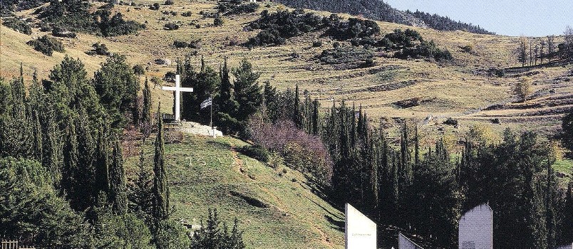
At the place of execution, the White Cross and the Mother of Kalavrita, eternal symbols of martyrdom, continue to send messages of peace and brotherhood to the peoples of the world.
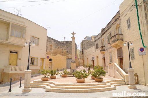
Municipality of Zurrieq Malta
Municipality of Zurrieq Malta
Address: Ċentru tal-Komunita’ Joe Cassar,
Pietru Pawl Saydon Street, Żurrieq ZRQ 1030
TWINNING DATE:
Cyprus: 7/10/2000 under Mayor Antigoni Papadopoulou
Abroad: 1/3/2003
The small town of “Zurrieq” with its about 12,000 inhabitants has been twinned with Morphou since October 2000.
Zurrieq is a small town in the SE part of Malta, 10 kilometers from the capital Valletta. Built near the sea, in a barren corner of the island, it seems cut off from the rest of the island. The locals work in tourism and fishing. However, the city has a history with worth-visiting archaeological and historical sites.
One can find the Church of Saint Catherine, built in 1630 with paintings by the famous Maltese artist PRETI.
A Roman tower, a tomb of the Phoenician period of the 2nd century AD and buildings of the 15th and 16th centuries make the city a picturesque and beautiful place.
The ruins have features that characterize the various settlements of the peoples inhabiting the area, from the Phoenicians, the Carthaginians, the Greeks and the Romans, while other excavations refer to findings from the Bronze Age and relics of 200 AD.
In addition to the Cathedral dedicated to Saint Catherine of Alexandria, who’s feast day is on July 16, the city is full of chapels, such as:
- The Bubaqra chapel dedicated to the Assumption of Virgin Mary
- The Nigret chapel dedicated to the Immaculate Conception of Virgin Mary
- The Hal-Millieri chapels dedicated to the Annunciation of Virgin Mary and Saint John
- The chapel of St. Leone
- The chapel of Santa Agata
- The chapel of Saint James
- The chapel of St. Bartholomew
- The chapel of St. Andrew
- The chapel of St. Luke
Municipality of Nea Orestiada
![]()
Municipality of Nea Orestiada
Address: 9-11 Vasileos Konstantinou Orestiada, PC 68200
Email: [email protected]
URL: https://www.orestiada.gr
TWINNING DATE:
Cyprus: 10/7/2000
Abroad: 3/3/2001 under Mayor Antigoni Papadopoulou in Orestiada
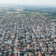
MUNICIPALITY OF ORESTIADA
Orestiada, or New Orestiada, is located in the northeast part of the prefecture of Evros in Thrace and is the seat of the homonymous municipality. It is 977 km away from Athens, 425 km away from Thessaloniki, 91km away from Alexandroupoli, 212 km northwest of Constantinople and just 19 km south of Adrianople. Learn more
Municipality of Saint Cyr Sur Loire, France
Municipality of Saint Cyr Sur Loire, France
Address: Parc de la Perraudière – BP 50139
37541 Saint-Cyr-sur-Loire cédex
Telephone: 02 47 42 80 00
TWINNING DATE:
Cyprus: 19/10/2002 under Mayor Mr. Charalambos Pittas
Abroad: 14/10/2201
Perhaps the best ambassadors of Cyprus, who could talk to us with their innocent souls about this city, are our own children, the children of Morphou, who stayed a few nights in this beautiful city of Central France.
In recent years, children from Morphou have been hosted in Saint-Cyr – Sur – Loire peoples’ homes on the occasion of a pan-European football tournament for children aged 10-13, the “Europousse”.
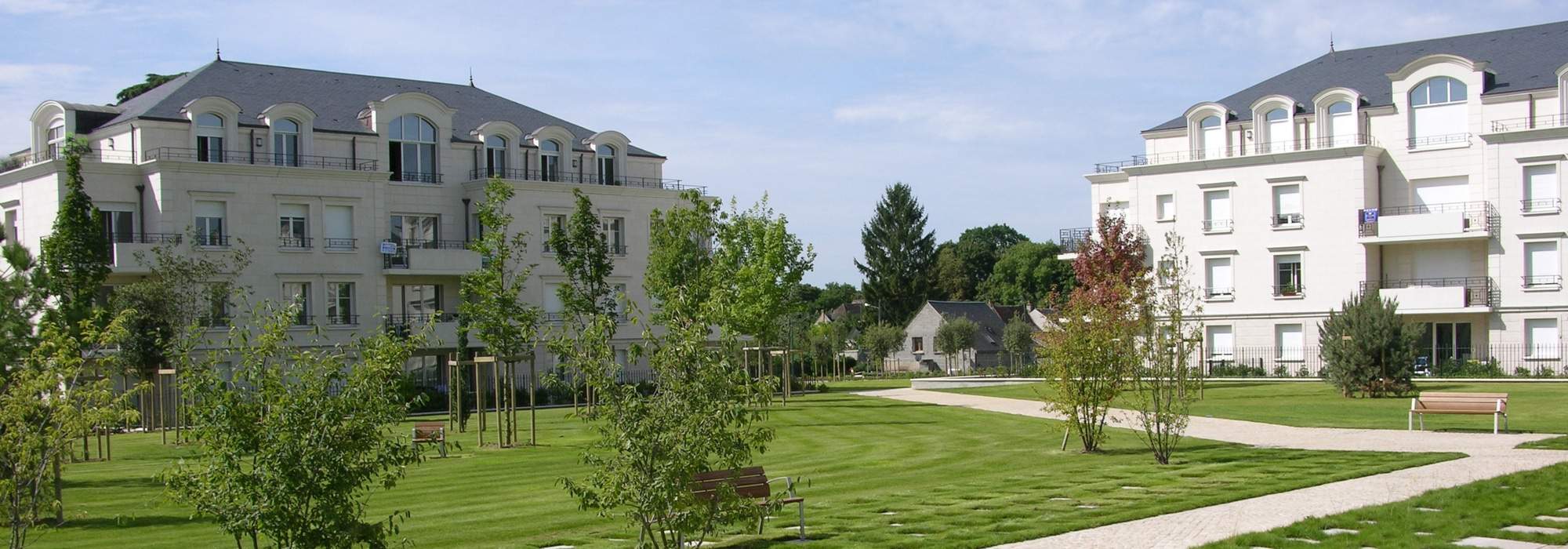
The city of Saint Cyr Sur Loire, “Saint Cyril built on the Loire River”, is a beautiful suburb of the city of Tours. The Loire River, which crosses France from east to west and ends in the Atlantic Ocean, divides them
Both are built in the Central Plain of France, which is full of vineyards that give France its famous wines. Their magnificent castles – palaces are now a jewel of Central France and are a pole of attraction for both French and European visitors.
Saint Cyr Sur Loire and the Tour along with other cities in the region are one of the 83 French provinces of “Indre – et – loire” created during the French Revolution on 4 March 1790.
The region has been an educational center throughout the Middle Ages until today. Until the end of the 19th century, the area remained a large agricultural center. In the first decades of the 19th and with the advent of the railway, industrialization took place and apart from educational center, the area was transformed into an industrial center, especially in the manufacture of railway machines.
Saint Cyr Sur Loire is developing and becoming a suburb for the rich bourgeoisie of the area. A relatively low-key city without large buildings and blocks of flats, with clean streets and squares, without large industrial units and shopping centers, it keeps its own character and pride.
Municipality of Messolonghi
Municipality of Mesolongi
Address: Stavropoulou 31, Mesolongi, PO 30200
Phones: 2631360913, 2631360993
Fax: 2631025041
Email: [email protected]
TWINNING DATE:
Cyprus: 31/08/2002
Abroad: 02/05/2003 under Mayor Mr. Charalambos Pittas in Mesolongi
The history of the city from antiquity to the present
Mesolongi (officially the Holy City of Mesolongi) is the capital of the Prefecture of Aitoloakarnania. It is located in the southern part of the Prefecture, between the rivers Acheloos and Evinos, about 35 kilometers away from Agrinio and 37 kilometers away from Antirrio.
It is a historic municipality as some of the most dramatic moments of the Greek Revolution of 1821 took place in the city, the two Sieges and the Exodus of Mesolongi.
Mesolongi is also known for its fishery products, especially bottarga, as the adjacent lagoon is an ideal place for aquaculture.
The lagoon with its picturesque ‘Pelades’ – small wooden houses on piles in the water – is protected by the well-known RAMSAR Convention and is an environmental park and ecosystem.
The name Mesolongi was first mentioned by a Venetian, who described Lepanto’s battle near Nafpaktos. Several historical sources indicate that the name Mesolongi comes from the combination of the two Italian words, MEZO / MESSO and LAGHI, which means “a place in the middle of a lake” or “a place surrounded by a lake”. Until 1700, the city was under Venetian occupation. Its inhabitants were mainly fishermen.
To the northwest of Mesolongi lie the ruins of Pleuronas (“Asfakovouni”), a city mentioned in Homer’s works. He took part in the Trojan War and was destroyed by Demetrius Aetolicus. The new city, built on the ruins of the old one, was one of the most important of Aetolia and had 30 towers and 7 gates. Excavations at Pleuronas have exposed the walls, the city’s theater, tombs, a Roman aqueduct and many buildings.
During the 1770 revolution, the city’s army was defeated by the Ottomans. Mesolongi rebelled again on May 20, 1821 and was one of the main Greek forces in the liberation struggle. The inhabitants resisted the attacks of the Ottoman Empire in 1822 and 1823 (Second siege of Mesolongi). The third attack was launched on April 15, 1825 by Koutachis, whose army numbered 30,000 men and was later reinforced by another 10,000 led by Ibrahim. Among the Ottoman army there were 3,000 Myrdites, that is, Catholics from northern Albania (referred to as “Latins”) and 700 Russian Don Cossacks.
After a year of constant attacks and hunger, the inhabitants of Mesolongi decided to leave the city on the night of April 10, 1826, which became known as the “Exodus of Mesolongi”. At that time the population of the city was 10,500 of which 3,500 were armed. Only a few people from Mesolongi survived the Exodus. Due to their heroic attitude, the city accepted the honor of being given the title of Sacred City, which is unique in Greece.
The famous philhellenes English poet Lord Byron, who supported the Greek struggle for liberation, died in the city in 1824. There is a reference to his person in a cenotaph containing his heart.
Municipality of Slovenj Gradec, Slovenia
SLOVENJ GRADEC, SLOVENIA
Website: www.slovenjgradec.si
Slovenj Gradec is the cultural and economic centre of the Mislinja river valley. With its number of inhabitants, it is a small town, but when you take its artistic tradition and institutions into account, its importance extends over many borders. Numerous exhibitions in the art gallery and events (some of them under the aegis of the UN) have promoted the town worldwide, and that is how in 1989 Slovenj Gradec got the distinguished title of the Peace Messenger City. It was the first city in Slovenia to receive this honorary title by the then Secretary-General of the United Nations, Javier Perez de Cuellar.
Slovenj Gradec City Municipality has its headquarters in Slovenj Gradec town centre, at the Town Hall, Šolska Street No. 5 since its establishment in 1995. Rotenturn Castle, a medieval building, was renovated in the late eighties and from early nineties, it is also the seat of the town administration. Slovenj Gradec is the administrative economic and cultural centre of this valley. With its number of inhabitants – 17.000 people live in the whole municipality – it is a smaller town. Still, but when you consider its artistic tradition and cultural and other institutions, its importance extends over many borders. Slovenj Gradec is the only »city municipality« in the statistical region of Koroška (Carinthia) and one of eleven city municipalities in Slovenia. Slovenj Gradec city administration has 54 employees, which places the company among the mid-sized companies of public law, specifically the local self-government institutions.
Since the elections in 2018 the Slovenj Gradec Mayor has been Mr Tilen Klugler.
The historical image of Slovenj Gradec and its surrounding area stretches back to prehistoric times and may be traced to the remains of the Illyrian and Celtic settlement called Colatio. The medieval town was (like the other oldest Slovene towns) founded in the 13th century. It has survived centuries of turmoil but the town folk (most often artisans and merchants), together with foreign and native masters and artists, have managed to care for the image of the town. The old town centre has remained the focus of cultural and social life right up to the present day. Slovenj Gradec has always been and remains rooted within its historical and cultural tradition. The most famous artistic monuments in the town are the Gothic church of the Holy Spirit and the church of St. Elizabeth; it is also interesting to examine the old town centre which has been preserved in its original design. In the nearby surroundings, there are quite a few cultural and historical monuments, whose characteristics resonate in a broader cultural context. The most important is the church of St. George at Legen, followed by the ruins of Vodriž castle and the church of St. Pancras above Stari trg (the Old Square). Some sites of ethnological interest have also been preserved. Among them, we find many traditional Slovene hayracks, old peasant houses, chapels and, here and there, a few old watermills and sawmills.
In Slovenj Gradec there are also the birthplaces and places of creativity of numerous famous people, such as one of the last European printers of the “Incunabula”, Mateusz Cerdonis; the Baroque painter Franc Strauss, the composer Hugo Wolf, of whom 160th birth anniversary we are celebrating in 2020, the poet Ernst Goll, the sculptor Franc Berneker, the writers Franc Ksaver Meško and Ljuba Prenner, the painters Jože Tisnikar, Bogdan Borčič, Karel Pečko and many others. Traditional artisan work has also been handed down to contemporary masters, working from their homes.
Slovenj Gradec is internationally active, with its six twinned towns: Gornji Milanovac (Serbia), Cesky Krumlov (Czechia), Hauzenberg (Germany), Voecklabruck (Austria), Myoko (Japan) and Morphou (Cyprus). The cultural cooperation charter was signed with the Slovak town of Bardejov as well.
Twinning with Morphou was signed in 2008, during Slovenian presidency of EU. However, first contacts with Morphou were established in 1998, when Morphou was designated a Peace Messenger City at the General Assembly of the International Association of Peace Messenger Cities (IAPMC) in Pori, Finland. Ever since Morphou represents one of the pillars of the IAPMC and both towns are jointly contributing to the activities and programme of the association, Morphou as president or vice-president and Slovenj Gradec as Secretary-General since 2007.
Since municipalities in Slovenia are responsible for communal, street and housing infrastructure, preschool education, culture, primary health services and general safety and well-being, prosperity and progress of their citizens, Slovenj Gradec City Municipality is no exception. With its sustainable development goals, which became its vision and strategy in the last years, it is placed among the top 50 municipalities in Slovenia in which people would like to live. With its efforts in maintaining a clean, well preserved and beautiful landscape, it is also acquiring high marks in tourist competitions in Slovenia, which attracts many visitors every year.